Long Range GFS
Page 3 of 4 •  1, 2, 3, 4
 ![]()
Re: Long Range GFS
![]() jrosson Wed Apr 15, 2009 9:33 pm
jrosson Wed Apr 15, 2009 9:33 pm
jrosson- Posts : 57
Join date : 2009-03-05
Age : 37
Location : Norman and Kellyville
Re: Long Range GFS
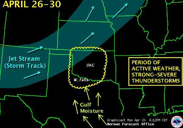
![]() Sam Mon Apr 20, 2009 5:51 pm
Sam Mon Apr 20, 2009 5:51 pm
[img]
 [/img]
Sam- Admin
- Posts : 439
Join date : 2008-10-30 -

bmac87- Posts : 365
Join date : 2008-10-31
Re: Long Range GFS
![]() Sean Mon Apr 20, 2009 9:22 pm
Sean Mon Apr 20, 2009 9:22 pm
My god, it's been so long I didn't even think the scale went that high anymore!
Sean- Posts : 94
Join date : 2008-10-30
Re: Long Range GFS
![]() Sam Tue Apr 21, 2009 6:33 am
Sam Tue Apr 21, 2009 6:33 am
Similar to what OUN is showing here .... http://www.srh.noaa.gov/oun/enhanced.php?map=4
GFS showing widespread 60+ Td's and 3000 CAPE. If things continue to trend towards a possible chase, we can start a Forecast Thread soon.
Sam- Admin
- Posts : 439
Join date : 2008-10-30 -
Re: Long Range GFS
![]() bmac87 Tue Apr 21, 2009 10:11 am
bmac87 Tue Apr 21, 2009 10:11 am
bmac87- Posts : 365
Join date : 2008-10-31
Re: Long Range GFS
![]() bmac87 Thu Apr 23, 2009 9:15 am
bmac87 Thu Apr 23, 2009 9:15 am
00z run: 192 hours: 4293 J/kg CAPE over Norman... damn...
bmac87- Posts : 365
Join date : 2008-10-31
BAD TIME FOR MULTIPLE CHASE DAYS!!!!!!!!!!!!!!
![]() Sam Fri Apr 24, 2009 6:54 am
Sam Fri Apr 24, 2009 6:54 am
Sam- Admin
- Posts : 439
Join date : 2008-10-30 -
May 9-10
![]() Sam Sun May 03, 2009 11:41 am
Sam Sun May 03, 2009 11:41 am
Sam- Admin
- Posts : 439
Join date : 2008-10-30 -
bmac87- Posts : 365
Join date : 2008-10-31
Re: Long Range GFS
![]() Sam Mon May 04, 2009 7:41 am
Sam Mon May 04, 2009 7:41 am
Sam- Admin
- Posts : 439
Join date : 2008-10-30 -
Re: Long Range GFS
![]() Sam Wed May 06, 2009 7:30 am
Sam Wed May 06, 2009 7:30 am
Sam- Admin
- Posts : 439
Join date : 2008-10-30 -
Re: Long Range GFS
![]() Sam Fri May 08, 2009 10:42 am
Sam Fri May 08, 2009 10:42 am
After that GFS, ECMWF, and ensembles show slight western ridging with possible WNW or NW 500 flow for a while. more derecho chasing
Sam- Admin
- Posts : 439
Join date : 2008-10-30 -
Re: Long Range GFS
![]() Sam Mon May 11, 2009 1:14 pm
Sam Mon May 11, 2009 1:14 pm
Enough said ->
http://www.meteo.psu.edu/~gadomski/ECMWF_12z/hgtcomp.html
Sam- Admin
- Posts : 439
Join date : 2008-10-30 -
Re: Long Range GFS
![]() Sam Sun May 17, 2009 9:03 am
Sam Sun May 17, 2009 9:03 am
Sam- Admin
- Posts : 439
Join date : 2008-10-30 -
Re: Long Range GFS
![]() bmac87 Sun May 17, 2009 11:03 am
bmac87 Sun May 17, 2009 11:03 am
bmac87- Posts : 365
Join date : 2008-10-31
Re: Long Range GFS
![]() Sean Sun May 17, 2009 4:22 pm
Sean Sun May 17, 2009 4:22 pm
Sean- Posts : 94
Join date : 2008-10-30
Re: Long Range GFS
![]() Sam Sun May 17, 2009 9:07 pm
Sam Sun May 17, 2009 9:07 pm
Sam- Admin
- Posts : 439
Join date : 2008-10-30 -
Re: Long Range GFS
![]() Sam Fri May 22, 2009 10:56 am
Sam Fri May 22, 2009 10:56 am
Sam- Admin
- Posts : 439
Join date : 2008-10-30 -
Re: Long Range GFS
![]() Sam Sat May 23, 2009 7:22 pm
Sam Sat May 23, 2009 7:22 pm
Synoptic responses during the past week or so included the zonal mean storm track shifted anomalously poleward over the Northern Hemisphere, continuation of anomalous extratropical ridges (both hemispheres) with low pressure across the subtropics, and Western Hemisphere subtropical jets. Cutting to the chase, I do expect the latter to shift poleward and bring the Northern Hemisphere storm track southward (including the lower 48 states) over the next 2-3 weeks. During roughly days 10-20 a couple of strong progressive troughs across the western into the central states (north of ~35-40 degrees) is still possible should there be some form of GWO 7-8-1 transition. Maybe there is still some hope for project VORTEX!
Sam- Admin
- Posts : 439
Join date : 2008-10-30 -
Re: Long Range GFS
![]() bmac87 Sun May 24, 2009 5:06 pm
bmac87 Sun May 24, 2009 5:06 pm
bmac87- Posts : 365
Join date : 2008-10-31
Re: Long Range GFS
![]() Sam Fri May 29, 2009 11:09 am
Sam Fri May 29, 2009 11:09 am
12z GFS from today, goes back to the solution from a couple of days ago and wants to eject that California low out into the plains late next week into the weekend. If that happens, then we're in business!!!! We'll see if the 12z ECMWF agrees with this idea or not.
I probably won't be posting any forecast thread stuff since ya'll are all out and I would just be posting it for myself.
I'll post reports on here and updates on blog though.
Sam- Admin
- Posts : 439
Join date : 2008-10-30 -
Re: Long Range GFS
![]() Sam Fri May 29, 2009 7:27 pm
Sam Fri May 29, 2009 7:27 pm
"DEVELOPMENT OF A MEAN UPPER LEVEL
TROUGH OVER THE WESTERN UNITED STATES DURING WEEK TWO IS CONSISTENT
WITH THE GWO AND LIKELY WILL OCCUR AS ENHANCED TROPICAL THUNDERSTORM
ACTIVITY SPREADS EASTWARD. A VERY ACTIVE PERIOD OF SEVERE WEATHER IN
THE CENTRAL PLAINS IS LIKELY IN MID JUNE."
Sam- Admin
- Posts : 439
Join date : 2008-10-30 -
JUNE 2ND/3RD
![]() jrosson Mon Jun 01, 2009 11:17 pm
jrosson Mon Jun 01, 2009 11:17 pm
LAST I HEARD VORTEX WAS IN SD. GOOD LUCK ENJOY THE TRIP.......
jrosson- Posts : 57
Join date : 2009-03-05
Age : 37
Location : Norman and Kellyville
Page 3 of 4 • 1, 2, 3, 4 ![]()
|
|
|